Forest Society of Maine

Your land trust for Maine's North Woods.
.

  • Facebook
  • Instagram
  • LinkedIn
  • Home
  • About
    • Committed to Diversity
    • All About FSM
    • Mission
    • F.A.Q.s
    • Staff
    • Directors and Advisors
    • Job Openings
    • Swan Internship
  • Conserved Lands
    • FSM Conserved Lands
    • Projects Under Way
    • Caring for Conserved Lands
    • Statement of Conservation Position
  • Forests & Climate
    • FSM Conservation and Carbon Sequestration
    • Partnerships to Improve Fish Passage and Climate Resilience
    • Fighting for the Forests’ Future
    • Wood’s Role in Net Zero Carbon Buildings
    • Maine Won’t Wait
    • Forest Carbon Task Force
    • Maine’s Carbon Budget
  • Wabanaki Engagement
    • FSM’s Wabanaki Engagement
    • Organizational Growth
    • Learning / Participation
    • Action
    • Resources
  • News
    • FSM in Print
  • Support FSM
    • Ways to Give
    • Financial Statement
    • FSM’s Supporters
  • Accessibility
    • Recite Me User Guide
  • Contact

The Bogs of Coburn Gore

January 29, 2021 By Annie

Article originally published in the 2020 fall edition of Forest View, FSM’s biannual newsletter.

A bog in Coburn Gore in western Maine.
A bog in Coburn Gore visited by FSM stewardship staff last November shows some autumn color (and snow). FSM photo.

About 35,000 years ago, a carpet of ice thousands of feet thick covered much of New England. At one point all of Maine was hidden beneath the Laurentide Ice Sheet, even the highest points on Katahdin.  Evidence of this history is easy to find: deposits of sand, till, and large boulders known as glacial erratics that were left behind as glaciers retreated 10,000 years ago are still common on Maine’s landscape today.

In Coburn Gore, where FSM is working with family landowners to conserve approximately 8,300 acres, glaciers have helped to create natural features such as steep cliffs and kettlehole bogs. The Maine Natural Areas Program (MNAP) describes kettlehole bogs as “flat peatlands that formed in “kettles”—circular or elliptical depressions in glacial deposits created by the melting of buried ice blocks.” If you were to fly over Maine’s North Woods, you would likely notice the kettlehole bogs by the vibrant red color of the sphagnum moss (Sphagnum rubellum)—also known as peat—that grows there.

Bogs are highly acidic environments and wet soils are low in oxygen. Few plants are adapted to survive in these conditions. Besides peat, common bog plants include small cranberry (Vaccinium oxycoccos), leatherleaf (Chamaedaphne calyculata), and black spruce (Picea mariana). Kettlehole bogs are also often home to carnivorous sundew (Drosera family) and pitcher plants (Sarracenia purpurea).

Upper Hathan Bog, also in Coburn Core, is a roughly 200-acre bog that supports an MNAP-mapped Northern White Cedar Swamp. One cedar cored there was determined to be more than 180 years old! Mature cedar stands are important because they provide shelter and winter food for white-tailed deer. Upper Hathan also contains swamp fly honeysuckle (Lonicera oblongifolia), which is native to Maine, but rare because it only grows in cool cedar swamps with limestone beneath them.

Conservation at Coburn Gore will ensure that all of its significant bogs, as well as its productive forestlands, will remain undeveloped in perpetuity. If you would like to learn more about the Coburn Gore Forest project, please visit fsmaine.org/conserved-lands/projects-under-way/.
 

Filed Under: Blog Tagged With: Coburn Gore, western mountains

American History in Coburn Gore

June 26, 2020 By Annie

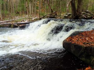
Benedict Arnold and his men would have encountered streams like this one, and the dense forest behind it, while trekking through Coburn Gore.

The Forest Society of Maine has a unique opportunity to conserve land in western Maine that is not only scenic and ecologically valuable, but is also known for being an American Battlefield of the Revolution. Coburn Gore Forest, bordered on three sides by Quebec, is the site of the last leg of the journey of the Benedict Arnold Expedition where he led more than 1,000 men from the Kennebec and Dead Rivers into Quebec to attack the Province in 1775. His attack ultimately ended in defeat. Painstakingly blazing their way through dense wilderness, the route, trail, or march as it’s known, was rife with suffering and hardship. Arnold lost one-third of his men on the journey and finally had to abandon the heavy, cumbersome bateaux (large wooden boats) used to travel up river from the coast.

The remoteness and terrain of the Chain of Ponds area around Coburn Gore has helped to preserve the archaeological sites along this historic route. As recently as 2017, the Maine Historic Preservation Commission, along with the Arnold Expedition Historical Society (AEHS), identified and assessed several more significant sites along the trail route. The Arnold Trail to Quebec was listed in the National Register of Historic Places in 1969. The exact trail location is not yet known but according to Kenny Wing of the AEHS, “every year we are narrowing down the trail more and more based on archaeological information.” FSM is working with a family landowner to establish a working forest conservation easement on 8,300 acres of Coburn Gore. This easement will not only prohibit residential and commercial development, but will forever protect the lands supporting the historic Arnold Trail.

Filed Under: Blog, Featured Tagged With: Coburn Gore

The Power of Connectivity

January 10, 2020 By Annie

Looking south across Arnold Pond at Coburn Gore Forest in western Maine, near the Quebec border.
Looking south across Arnold Pond at Coburn Gore Forest.


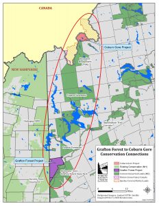
Have you ever experienced the solitude of hiking for miles without seeing any buildings? On the other hand, have you ever watched wildlife try to cross a busy road? Experiences like this highlight how meaningful an interconnected landscape is for people and animals. That’s why the Forest Society of Maine (FSM) is thrilled to announce that two of our newest conservation projects in western Maine add to a continuous corridor of conserved land stretching across the western edge of Maine from New Hampshire to Canada. The Grafton Forest project and Coburn Gore Forest project encompass working forestlands that provide employment and raw materials for a variety of workers and businesses. Connected landscapes benefit forest management, enhance wildlife habitat, and provide resilience in the face of climate change.

Coburn Gore Forest Project

The 8,300-acre project area in Coburn Gore Township has been owned by the same family for decades. It boasts an exceptionally well-managed forest. The lands encompass the headwaters of the Dead River and Kennebec River; a grove of old growth trees, a unique bog ecosystem, and two state-designated Heritage brook trout ponds. Lands to the west and north of the Coburn Gore property, in Québec, are conserved provincial forest and recreation lands. To the south is the Boundary Headwaters Conservation Easement, conserved by FSM more than a decade ago.

Map showing corridor of conserved lands stretching from New Hampshire border to Quebec that these projects will help complete.
Click to enlarge.

In addition to the vast array of natural resource features, it has historical significance because the route Benedict Arnold took to Québec during the Revolutionary War traverses the property. Several important Arnold-related archaeological sites have been documented by the Maine Historic Preservation Commission and Arnold Expedition Historical Society. While remote, the property is adjacent to a transnational border crossing. Bringing conservation to Coburn Gore Forest will conserve its many habitats, natural resources, and scenic values in perpetuity and ensure that forest management can continue.

Grafton Forest Project

The Grafton Forest Project is located in Grafton, Riley, and Andover North Surplus Townships. Comprised of 21,300 acres this forest lies in a spectacular valley setting that showcases the surrounding mountain ranges and is highly visible from numerous mountain peaks such as Old Speck. It is frequented by people who hike, ski, snowshoe, and run dogsleds on the property. Local ATV and snowmobile clubs have also created an extensive network of trails that run through the property to adjacent trails in New Hampshire. To the east lies Grafton Notch State Park/the Mahoosuc Unit and a long stretch of the Appalachian Trail (AT) known for some of the most difficult terrain in the state. Within the project boundaries, there are two side trails that hikers use to access the AT. The easement will ensure the permanence of the trails, as well as continued public access to them. The easement is designed to permit sustainable forest management and will prohibit commercial and residential development. The project is widely supported by surrounding communities as it will sustain recreational activities on the property and buffer subdivision and development pressures from the south.

FSM will be working over the next few years to secure funding for these exceptional forest conservation easement projects. These projects present a wonderful chance to conserve and connect, forever, the ecological, economic, recreational, and cultural values across the western Maine mountains.

Filed Under: Blog, News Tagged With: Coburn Gore, Grafton

Land Trust Accreditation Notice

May 21, 2025

The land trust accreditation program recognizes land conservation organizations that meet national quality … [Read More...]

Blog Posts

  • Tree Giveaway Day May 21, 2025
  • Land Trust Accreditation Notice May 21, 2025
  • Drinking Water Week May 9, 2025

Forest Society of Maine

209 State St, 2nd Floor
Bangor, Maine 04401
(207) 945-9200
info@fsmaine.org

Sign up for FSM's E-News

  • Email
  • Facebook
  • Instagram
  • LinkedIn

Copyright © 2025 Forest Society of Maine · All Rights Reserved

Built with RainStorm Foundations & WordPress