Forest Society of Maine

Your land trust for Maine's North Woods.
.

  • Facebook
  • Instagram
  • LinkedIn
  • Home
  • About
    • Committed to Diversity
    • All About FSM
    • Mission
    • F.A.Q.s
    • Staff
    • Directors and Advisors
    • Job Openings
    • Swan Internship
  • Conserved Lands
    • FSM Conserved Lands
    • Projects Under Way
    • Caring for Conserved Lands
    • Statement of Conservation Position
  • Forests & Climate
    • FSM Conservation and Carbon Sequestration
    • Partnerships to Improve Fish Passage and Climate Resilience
    • Fighting for the Forests’ Future
    • Wood’s Role in Net Zero Carbon Buildings
    • Maine Won’t Wait
    • Forest Carbon Task Force
    • Maine’s Carbon Budget
  • Wabanaki Engagement
    • FSM’s Wabanaki Engagement
    • Organizational Growth
    • Learning / Participation
    • Action
    • Resources
  • News
    • FSM in Print
  • Support FSM
    • Ways to Give
    • Financial Statement
    • FSM’s Supporters
  • Accessibility
    • Recite Me User Guide
  • Contact

Fish River Lakes Conservation Easement Completed

June 18, 2021 By Annie

PRESS RELEASE:

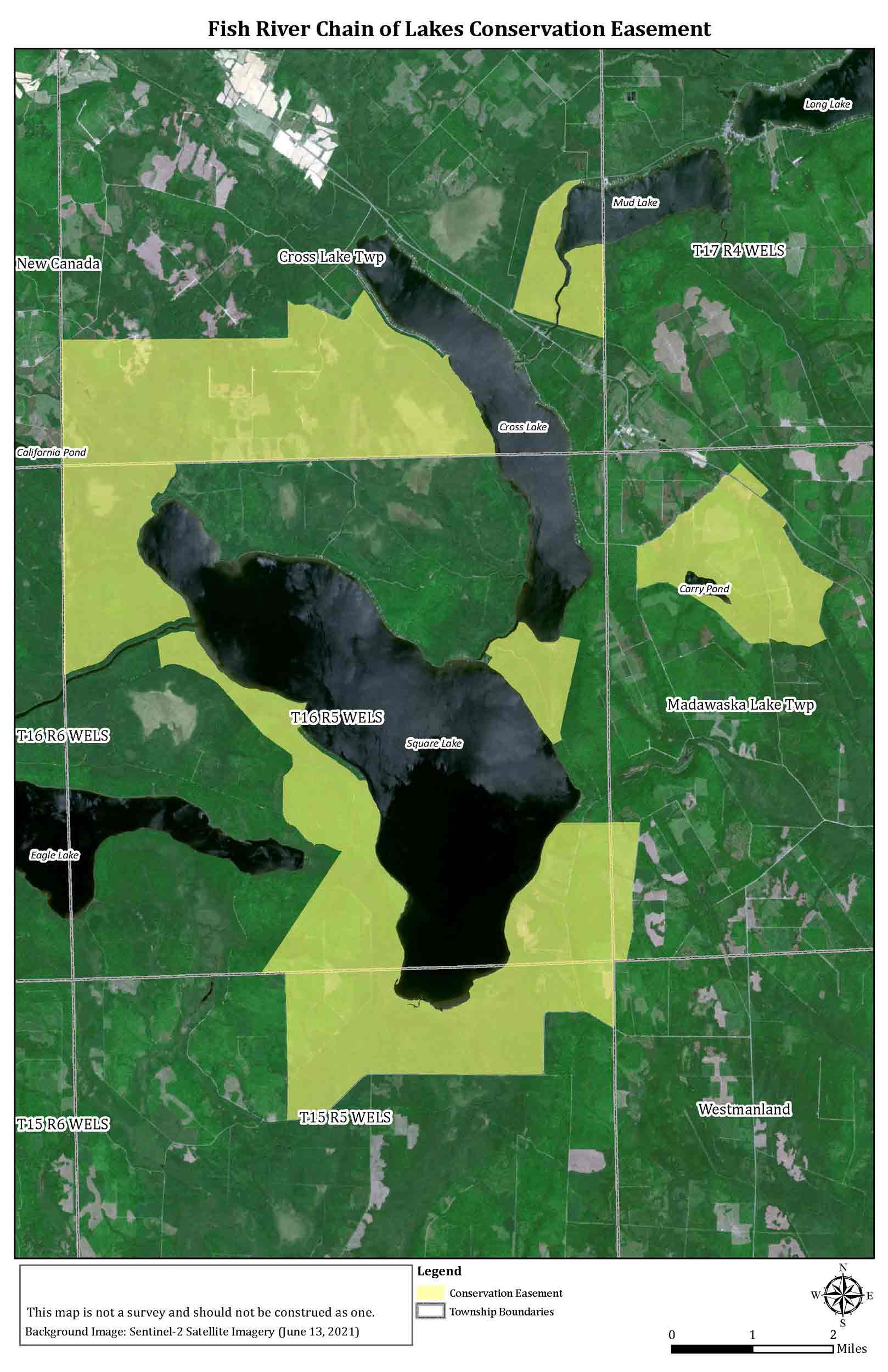
The Forest Society of Maine announced the completion of a forest conservation easement on lands owned by Irving Woodlands in the Fish River Chain of Lakes region in Aroostook County, Maine. This permanent easement, encompassing some 16,900 acres, is strategically located to provide natural resource protections for the lands around Mud Lake, Cross Lake, and Square Lake—known to many as the Fish River Chain of Lakes. Going forward the Forest Society of Maine has the responsibility of stewarding the permanent working forest conservation easement.

“These lands support many conservation values including diverse plant and wildlife habitats, including streams that are home to brook trout, rainbow smelt, and landlocked salmon,” stated Karin Tilberg, Forest Society of Maine President/CEO. “We are tremendously pleased to have worked with the Irving team and through the Land Use Planning Commission (LUPC) process to develop a meaningful conservation easement for these lands.”

The conservation easement ensures the forests won’t be developed or converted to other uses not compatible with sustainably managed forests. It protects the majority of the shoreline around Square Lake and Carry Pond and the streams that feed them and requires that all forestry activities are implemented as part of a forest management plan. The easement also creates a permanent right of pedestrian public access on the lands for low intensity outdoor recreation.

The Fish River Conservation Easement was developed during a public process connected with the Lake Concept Plan developed by Irving Woodlands and approved in late 2019 by LUPC. “We are pleased to announce the signing of our Conservation Easement with the Forest Society of Maine as a component of the Fish River Chain of Lakes Concept Plan,” said Anthony Hourihan, Director Land Development of Irving Woodlands, “Responsible, well-planned development will provide new recreational and economic opportunities in Aroostook County while ensuring important conservation values are maintained for the long term. The Forest Society of Maine has been a great partner through this process by balancing the need for conservation with the need to maintain working forest which supports a critical industry in the County.”

A map showing conserved areas around Fish River Chain of Lakes.
(The light green areas indicate the land within the Fish River conservation easement.)

Filed Under: Blog, Featured, News Tagged With: Fish River

Trails Run Through It

May 24, 2021 By Karin Tilberg

Snow-crusted trees and endless mountains are visible from the summit of Old Speck in Maine's western mountains.
Maine’s western mountains from the summit of Old Speck. Photo by Maine Appalachian Trail Land Trust.

On a January morning the thermometer on my car read -12°F on what was the coldest day of the winter, so far. I was driving to meet conservation colleagues to climb Old Speck, following the Appalachian Trail (AT) to its summit. This section of the AT borders the Grafton Forest parcel that the Forest Society of Maine is seeking to conserve. When we headed up the trail, it had warmed to 6°F and the bright sun and brilliant snow dazzled us as we snowshoed 7.6 steep miles, round trip.

The Forest Society of Maine (FSM) is leading the effort to conserve approximately 21,300 acres of forestland that comprise the Grafton Forest project, and is joined by two partners, the Northeast Wilderness Trust (NEWT) and the Maine Appalachian Trail Land Trust (MATLT). FSM will be placing a working forestland conservation easement on the majority of the forestland. NEWT will take ownership of the higher elevation land and place a Forever Wild Easement on land that will be held by MATLT.

Grafton Forest is uniquely important to those who hike, maintain, and help provide rescue services for those on the AT. Two AT side trails, the Speck Pond Trail and the Notch Trail, cross the Grafton Forest project lands to connect with the bordering AT. The project will ensure these side trails and access to them will remain into the future. Dogsled, ski, ATV, and snowmobile trails also thread the property and are important to local residents.

Two people snowshoe uphill through snow-covered trees.
Snowshoeing to Old Speck. Photo by Maine Appalachian Trail Land Trust.

At the summit of Old Speck, we looked out over the Grafton Forest lands, stretching out to the west to form a magnificent viewshed for the AT. From the fire tower, there are 360-degree views of the snow bedecked mountains, lakes, and forests. Not only stunningly beautiful, the project area is also highly rated for terrestrial climate resilience by The Nature Conservancy and will form a bulwark against development pressure from the nearby Sunday River Ski Resort.

Gazing at the snow-covered mountain landscape I felt my spirits soar knowing of the strong partnerships with the landowner, many conservation and recreation organizations, and donors who are working with FSM to safeguard this special place. Conserving this area is vital for responding to climate change, maintaining working forests and wildlife habitats, and for the future enjoyment of all who are inspired by the vantage across Grafton Forest.

–Karin Tilberg
Article originally published in the 2021 spring edition of Forest View, FSM’s biannual newsletter.

Filed Under: Blog, Featured

Supporting the Forests We Cherish

December 1, 2020 By Annie


Maine is lucky to have so many remote and untrammeled places where we can recreate and enjoy nature. FSM’s mission is to help keep these forests as forests. This is only possible through the generosity of hundreds of people each year.

Many of us have spent time outdoors these past months hiking, camping, paddling, fishing, hunting, and more. If you are able, please consider making a contribution to FSM’s annual fund to ensure these opportunities remain and FSM’s work continues. Thank you!

Donate to FSM


Filed Under: Blog, Featured, Uncategorized

Capturing the Grafton Landscape

October 22, 2020 By Annie

Article originally published in the 2020 fall edition of Forest View, FSM’s biannual newsletter.
Sunrise over the Swift Cambridge River looking east over Popple Dam Rd in Grafton Township, Maine. Photo by Jerry Monkman, EcoPhotography.

Sometimes the best way to depict the essence of a place is not with words but with images. That is why photographer Jerry Monkman can be found waiting on a mountain summit before dawn with multiple cameras, ready to catch the first glow of light that seeps over the horizon, or on the shore of a tree-lined pond as evening light softens and fades. Dawn and dusk are excellent times to photograph, Jerry says, because this is when the landscape is the most dramatic and colorful. As a conservation photographer that specializes in scenic landscapes, his images grace the publications and websites of many conservation organizations and help to tell the stories of untrammeled places across Maine and New England.

This summer, the Forest Society of Maine (FSM) commissioned Jerry to showcase the beauty of the 21,300-acre Grafton Forest project which FSM is working to conserve. Jerry says that as he roamed the Grafton Forest lands he heard coyotes yip and howl in the distance and noted that there was moose sign everywhere. He describes York Pond as, “small and beautiful, idyllic and quiet, populated by beaver and ducks.”

With his photos, Jerry hopes to inspire people to care about natural and forested landscapes. At Grafton Forest, he spent hours driving dirt roads and hiking side trails, scouting the exact location from which to take the above shot. His images help us understand, even if we have never been there, what it feels like to watch the sun rise over the Mahoosuc mountains while shreds of mist float above the Swift Cambridge River. He’s spent more than 30 years looking through the lens of a camera, in all kinds of weather and locations. Being in remote places, like the rugged forests of western Maine, can be stressful—but it can also be meditative, and Jerry can’t imagine doing anything else.

“It’s my way of showing passion for wild places and open spaces,” he says. Now having hiked the ridgelines around Grafton Forest, Jerry can see that FSM’s project is an important one, “because conserving the lower slopes of one of the famed sections of the Appalachian Trail will also conserve the views from those peaks.”

Featured images from Grafton Township

View of Mt Washington from Grafton Notch, ME.
View of Mt. Washington from Grafton Township.
View of sun above western Maine mountains facing toward Success Pond.
Looking toward Success Pond.
Aerial view of York Pond in Grafton Township, Maine and the surrounding forest.
Aerial view of York Pond in Grafton Township and the surrounding forest.
Aerial view of the Swift Cambridge River in Grafton Township, Maine.
Aerial view of the Swift Cambridge River in Grafton Township.


Looking across York Pond in Grafton Township, Maine.
Looking across York Pond in Grafton Township.
To see more photos by EcoPhotography or learn more about Jerry’s work visit: ecophotography.com

Filed Under: Blog, Featured, News

American History in Coburn Gore

June 26, 2020 By Annie

Benedict Arnold and his men would have encountered streams like this one, and the dense forest behind it, while trekking through Coburn Gore.

The Forest Society of Maine has a unique opportunity to conserve land in western Maine that is not only scenic and ecologically valuable, but is also known for being an American Battlefield of the Revolution. Coburn Gore Forest, bordered on three sides by Quebec, is the site of the last leg of the journey of the Benedict Arnold Expedition where he led more than 1,000 men from the Kennebec and Dead Rivers into Quebec to attack the Province in 1775. His attack ultimately ended in defeat. Painstakingly blazing their way through dense wilderness, the route, trail, or march as it’s known, was rife with suffering and hardship. Arnold lost one-third of his men on the journey and finally had to abandon the heavy, cumbersome bateaux (large wooden boats) used to travel up river from the coast.

The remoteness and terrain of the Chain of Ponds area around Coburn Gore has helped to preserve the archaeological sites along this historic route. As recently as 2017, the Maine Historic Preservation Commission, along with the Arnold Expedition Historical Society (AEHS), identified and assessed several more significant sites along the trail route. The Arnold Trail to Quebec was listed in the National Register of Historic Places in 1969. The exact trail location is not yet known but according to Kenny Wing of the AEHS, “every year we are narrowing down the trail more and more based on archaeological information.” FSM is working with a family landowner to establish a working forest conservation easement on 8,300 acres of Coburn Gore. This easement will not only prohibit residential and commercial development, but will forever protect the lands supporting the historic Arnold Trail.

Filed Under: Blog, Featured Tagged With: Coburn Gore

  • 1
  • 2
  • Next Page »

Land Trust Accreditation Notice

May 21, 2025

The land trust accreditation program recognizes land conservation organizations that meet national quality … [Read More...]

Blog Posts

  • Tree Giveaway Day May 21, 2025
  • Land Trust Accreditation Notice May 21, 2025
  • Drinking Water Week May 9, 2025

Forest Society of Maine

209 State St, 2nd Floor
Bangor, Maine 04401
(207) 945-9200
info@fsmaine.org

Sign up for FSM's E-News

  • Email
  • Facebook
  • Instagram
  • LinkedIn

Copyright © 2025 Forest Society of Maine · All Rights Reserved

Built with RainStorm Foundations & WordPress